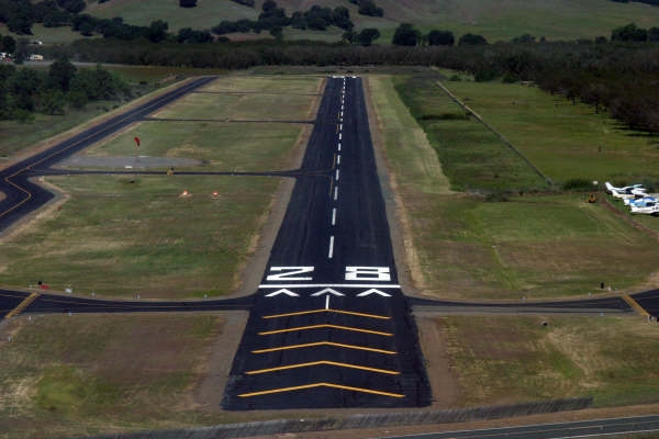
One Oscar Two
Airport News and Information


Notice:  LOP NDB Out of Service

The Lampson Non Directional Beacon (LOP NDB) is permanently Out of Service.


Notice:  PAPI Lights

The Runway 28 PAPI is set to 4.0 degrees. This is 1/3 steeper than the more normal 3 degrees.

Local Knowledge:  Look out below! and don't land short. Our rather steep PAPI glide slope angle, when combined with the 150 foot off-set threshold of Runway 28, provides aircraft a safe crossing height above the vehicle traffic using the roadway at the east end of the runway.


Airport Information
Field Elevation: 1,378
Location: 3 miles south of Lakeport
Coordinates: N 38-59.41 W 122-53.98
Magnetic Variation: 16 E

Nav aids: ENI 112.3 066°/17.9 NM

Frequencies
CTAF: 122.8 (unattended, no UNICOM advisory services provided)
AWOS: 118.35 or (707) 262-0380. Ceilings and sky conditions are not reported.
Oakland Center: 127.8
Oakland IFR Clearance Delivery: (510)745-3380
Oakland FSS: 123.6 or 122.35

Pilot Controlled Lighting
PCL is on 122.8 (CTAF). Lights are on the runway only with no taxiway lighting.

  • 3 clicks in 5 seconds for low intensity
  • 5 clicks in 5 seconds for medium intensity
  • 7 clicks in 5 seconds for high intensity

  • Local Knowledge:  Our pilots report that the lights don't activate from distances of more than about 6 miles from the airport.

    Runways
    10-28 3,600 x 60 asphalt.
    Runway 28 is the calm wind runway at Lampson Field.
    Runway Markings
    When using Runway 28, no taxi or take-off is allowed in the area marked by five (5) large yellow chevrons.
    This area is to be used only for additional stopping distance when using Runway 10.
    Traffic Pattern
    All traffic is on the north side of the runway:
    RIGHT traffic for Runway 28
    LEFT traffic for Runway 10

    Non-turbine pattern altitude is 2,400 MSL (1,000 AGL).
    Turbine pattern altitude is 2,600 MSL (1,200 AGL).

    Quiet Flying
    Lampson Field is surrounded by noise sensitive areas, including Lakeport, many lakeshore homes and several lakeside resorts.

    Our primary Quiet Flying Zone includes the commercial and residential areas located north of the airport traffic pattern. It is bounded by Clear Lake on the east and extends one-half (½) mile to the west of the freeway portion of Highway 29.

    The Quiet Flying Zone extends from the airport traffic pattern north to Sutter Lakeside Hospital, with its very visible helicopter landing pad (N 39-06.5 W 122-54.3).

    Please avoid flying in our primary Quiet Flying Zone below 3,500 MSL.


    Click here for Visitor Information

    Return to Home Page